After starting their career with the armed forces, drones are now entering civilian life—and creating concerns about safety
The Economist – Technology Quarterly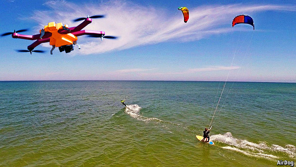
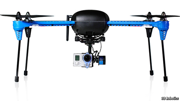
IT IS called an “airborne sidekick” by its Latvian manufacturer, Helico Aerospace Industries. But technically AirDog (pictured above) is a flying robot, or drone. The brightly coloured four-rotor quadcopter autonomously follows at a chosen altitude its master, who wears a wireless tracking device on his wrist. AirDog is designed to use its gyroscopically stabilised video camera to take action shots of skiers, bikers, kite surfers and other sporting activities. It is not the only “follow me” drone. IRIS+ (pictured), made by 3D Robotics, a Californian firm, can also follow a flight path mapped on a smartphone.
Ready-to-fly drones are now available from around $1,000. Some have been developed from radio-controlled model aeroplanes. But their ability at low cost to operate autonomously comes from the use of commodity electronics developed for consumer gadgets. Mobile phones, for instance, contain a number of devices useful in making drones, such as gyroscopes, accelerometers, wireless transmitters, signal processors and GPS units. As a result the use of drones is spreading rapidly beyond their now familiar military roles. Civilian drones are being used by businesses ranging from surveyors to utilities, delivery firms, news organisations and farms.
Businesses can save a lot of money with drones. Dillon Consulting, a Canadian company, hired one for about $7,000 to survey a landfill site in Ontario. It reckons chartering a manned aeroplane or helicopter would have cost at least three times as much. GeoGIS Consultants, a firm in Belgrade, Serbia, maps landscapes with lasers and other sensors for road and rail construction. It bought a drone two years ago for around $31,000 and stopped using manned aircraft. The drone’s cost was recovered in just two months, says Tosa Ninkov, the company’s owner.
Cancel the helicopter
Drones can improve safety, adds Dillon’s John Fairs. They are increasingly used to inspect wind turbines for cracks instead of workers kitted out with climbing gear. Drones are also being operated for power-line inspections. As this can involve lowering from a helicopter engineers clad in insulating suits and safety harnesses to crawl along a pair of high-voltage cables strung shoulder-width apart, it can be a “recipe for disaster”, adds Mr Fairs.
Data collected by drone are often more accurate than information gathered by other means. Fitted with two cameras for stereo vision, a drone called AeroHawk can map the dimensions and contours of a road at a resolution of about 2cm, says Scott McTavish, boss of a British Columbian firm called Accuas that surveys infrastructure. The best a commercial satellite can offer is about 30cm, but it could take more than four months to book one and might cost at least $10,000, adds Mr McTavish. The aircraft-like AeroHawk does not need a runway. It is tossed into the air and recovered by parachute.
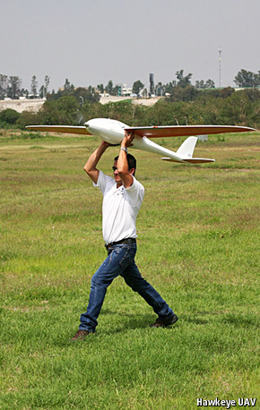
An AeroHawk in launch mode
Eight months ago Jean-Baptiste Bruggeman began flying a drone over his 210 hectares of farmland in La Louptière-Thénard, France. The robot’s multiple lenses photograph his fields from nine angles in infrared, near infrared and visible wavelengths. After the data are uploaded to a server, agronomists at Airinov, a Paris company, analyse details such as the level of moisture in the topsoil, the chlorophyll content of the crop and its biomass. Within 48 hours Mr Bruggeman receives an electronic map with encoded instructions. When uploaded to his GPS-equipped tractor, it automatically adjusts the spread of fertiliser to the optimal amount required for every part of his fields.
The benefits are enormous. Improving fertiliser allocation boosts yields enough to earn Mr Bruggeman, per hectare, an extra €50 ($64) for rapeseed and up to €100 more for wheat. The wheat’s protein content is also higher. As less fertiliser is applied, polluting run-off into streams is reduced. Mr Bruggeman is now starting a sideline to fly his drone for other farmers. Airinov already analyses drone data for more than 2,000 French farmers, and expects that to become 5,000 within a year.
Agriculture will be the biggest beneficiary of drones. Japanese farmers have used drones to boost yields by about 15%Besides surveying, drones can seed and spray fields without compacting topsoil or crushing plants. Large helicopter drones, such as Yamaha’s petrol-powered RMAX, fly lower than manned crop-dusting aeroplanes, so less pesticide is carried off by the wind. Rotor wash from the drone produces a finer mist and shakes leaves to help cover their underside with spray. By one reckoning, this cuts in half the amount of liquid that would otherwise be sprayed by tractor. The RMAX is widely used in Australia, Japan and South Korea. It is transported to fields in the back of a pickup truck, but costs a princely $125,000.
Bug hunting
Two years ago an insect-borne citrus disease called huanglongbing began ruining fruit and killing trees in southern California. Infected trees, which need to be cut down and removed quickly to prevent the disease from spreading, show a slight increase in temperature. This can be spotted by a drone carrying a heat-detecting camera which operates across a range of wavelengths and costs less than $5,000, says Sindhuja Sankaran, a biologist at Washington State University.
Temperature rises are typical in many diseased, parched or nutritionally deficient crops. So drones could have a wider role in keeping crops healthy. The Association for Unmanned Vehicle Systems International (AUVSI) believes agriculture will be the biggest beneficiary of drones. Japanese farmers have used drones to boost yields by about 15%, the industry group says. It reckons the commercial benefits from drones for the American economy are worth more than $10 billion a year.
But there is a problem in America. Flying small drones as a leisure pursuit is allowed under Federal Aviation Administration (FAA) guidelines used for model aircraft, which include staying below 120 metres, away from populated areas and having the craft in view at all times. But flying a drone for commercial purposes is largely banned and waivers are rare. It is not just farmers and surveyors who are affected, but also the film industry, which is keen to use them for action shots. Lawmakers, frustrated to see some American firms move their drone operations to Canada, Mexico and other countries where regulations are less restrictive, have ordered the FAA to come up with a set of rules by September 30th 2015 that will allow the flying of drones for commercial purposes.
If the rules are reasonable more than 70,000 jobs could be created within three years, says Mario Mairena, head of government relations for AUVSI. But many drone advocates are gloomy and fear that the FAA is using safety concerns to protect pilots’ jobs. There has been some heavy-handed action. An FAA policy statement in June forced dozens of universities to cancel engineering lessons that involved flying robots over campus lawns. The policy redefines the aircraft the FAA can ground so broadly it could include frisbees, laments Paul Voss, an aeronautics professor at Smith College in Massachusetts.
The FAA even fined a man $10,000 for flying a small styrofoam drone around a Virginia campus for a promotional video. (A judge overruled the fine but the agency has appealed.) The FAA rejects criticism of “regulatory overreach”. The agency maintains that it is required to protect people and property from injury, and that it has a duty to ensure drones do not interfere with manned aviation.
There is concern that the rules for civilian drones could be onerous. Brendan Schulman of Kramer Levin Naftalis & Frankel, a New York law firm, says that the FAA looks set to require even small drones to undergo a costly certification process—much like manned aircraft. He reckons regulators will allow daylight flights only with two licensed operators—who, like commercial airline pilots, must be medically approved—standing on the ground and keeping the drone in sight at all times.
Aviation authorities in other countries are also working on rules, but many seem more relaxed, provided basic safety procedures are followed.
Some people in America are not waiting for the FAA. Robert Blair of Kendrick, Idaho, uses a drone made from an $85 model aircraft to monitor his farm’s 607 hectares. It allows him quickly to spot diseases like wheat rust and with timely action can cut pesticide use by two-thirds. He says it is frustrating that agricultural drones are legally flown in Argentina, Australia, Canada and elsewhere. More American farmers now flout the FAA’s ban, he says, than the agency has resources to catch.
Nevertheless, there are risks. In February photojournalists at El Salvador’s biggest daily, La Prensa Gráfica, began taking pictures and video with three Phantom 2 Vision+ quadcopters. Each cost roughly $1,500 to import from DJI Innovations, a rapidly growing Chinese firm. Their aerial imagery boosted website clicks and embarrassed politicians who pledged to ease traffic gridlock only to see bird’s-eye shots of snarled-up roads. In April, however, one of La Prensa Gráfica’s drones nearly struck a power line and fell into a crowd attending a parade. Luckily no one was injured.
Operators are trying to improve safety. Drones often connect to a number of GPS satellites, so records of their flight paths are usually precise. 3D Robotics has put online a test version of a database to which the co-ordinates of flights will be uploaded from dozens of manufacturers’ drones. Unmanned aircraft synchronised to the system, called DroneShare, can then be instructed to follow routes that have already been safely navigated and avoid danger spots (a flagpole, say).
Prudence is in order, says Sean Cassidy, head of safety for the Air Line Pilots Association, International. He points to the US Airways plane that ditched safely on the Hudson River in New York in 2009 after its engines ingested geese, which are the size of some small drones. Software can help prevent that by automatically reining in drones if they venture too far or too high, says Josh Brookes-Allen, founder of Alphaflight Aerospace, an operator of cinematography drones in Sydney, Australia.
NASA, America’s space agency, is building an air-traffic-control system for drones. Operators will log on to a website and reserve blocks of airspace for flights. An early version of the system is expected online shortly. Flights will be forbidden near airports and capped at an altitude of about 120 metres. That leaves enough airspace for what Accenture, a consultancy, considers to be the most complex mission for civilian drones—automated delivery.
Amazon says that a drone-delivery service called Prime Air that it has tested in Canada will be ready by early 2015, assuming the FAA ban is lifted. Following recent testing in Australia, Google has also determined that deliveries with self-flying vehicles are practical, says Phil Swinsburg of Unmanned Systems Australia, a firm working on Project Wing, as the Google drone effort is known.
DHL, a logistics giant based in Germany, has already begun to deliver medicine by a “parcelcopter” drone (pictured) to Juist, a small island in the North Sea. An Australian startup called Flirtey expects to begin delivering books with six-rotor hexacopters before the end of the year. Delivery will cost more than sending the books in a van, at least initially. But it will be faster—Flirtey’s drones fly about 80km per hour (50mph) and pay no heed to traffic lights. Parcels are lowered from above to recipients. Matt Sweeny, the firm’s chief executive, is also talking to fast-food chains about drone delivery.
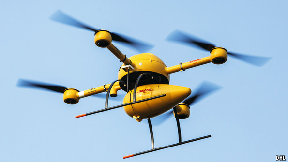
DHL’s parcelcopter leaves for work
Even in an all-terrain vehicle, a 150km slog on muddy roads in Papua New Guinea can take a day. With tuberculosis spreading, Médecins Sans Frontières, a French charity, would rather airlift saliva samples by drone from jungle collection centres to diagnostic labs. Matternet, a Silicon Valley firm hired to design the system, is working out a way to prevent the loss of a $5,000 drone in a distant treetop. Although guided by GPS, the drones relay flight data to their base through transmission towers for mobile phones. A drone struggling in a headwind can therefore be called back before its battery peters out.
Pallets of cargo could be hauled with big drones the size of some manned aircraft. With no on-board pilot or crew, the aircraft would hold more and weigh less. Simply building an aircraft with thinner walls for unpressurised flight reduces its weight by a tenth, says Hans Heerkens of Twente University in the Netherlands. He leads Platform Unmanned Cargo Aircraft, a group of more than 30 university and industry experts working on the concept.
Filing a flight plan
If drones are to fly in the same airspace used by manned aircraft, more collision-avoidance technology is needed. Passenger aircraft carry transponders that relay their position to ground radar. But an aircraft-type transponder would be too heavy for many small drones to carry, and with plastic or styrofoam airframes they might not be detected with radar.
Some drone developers propose using cameras with object-recognition processors to prevent collisions. But cameras cannot see through clouds and could be confused by a bug splat on the lens, says Mykel Kochenderfer, an aeronautics expert at Stanford University.
A more promising approach is offered by small on-board GPS-based devices that are part of a system called Automatic Dependent Surveillance-Broadcast (ADS-B). These devices repeatedly broadcast not just the aircraft’s position but other data, including its flight path. They also receive similar co-ordinates from any nearby aircraft. ADS-B is part of a new generation of air-traffic management being installed in America, Europe and elsewhere.
The ADS-B devices are light enough to be carried by many drones and more than 1,000 already have them, says Kelvin Scribner, boss of Sagetech, a firm in Washington state that sells an ADS-B device weighing a shade less than an iPhone. Even smaller versions are said to be on the way. ADS-B technology could be used to automate the management of both manned aircraft and drones flying in the same area of sky. Eventually it will form the backbone of drone safety, reckons Benjamin Trapnell, head of the University of North Dakota’s aviation department.
One problem is that GPS signals might be jammed, deliberately or inadvertently. Illegal jammers the size of a cigarette pack are widely sold for about $25 in eastern Europe to truck drivers disinclined to be tracked by their boss, says James Scanlan of the University of Southampton in Britain. His team are designing directional GPS antennae which are unlikely to be muddled by such interference. If a problem were to arise, he says, on-board gyroscopes and accelerometers would be able to work out a drone’s approximate position.
Yet risks go beyond accidents. It would not be difficult to rig a drone with a weapon or small bomb, so terrorism needs to be guarded against. And there may be no foolproof way to prevent a drone from being wirelessly hijacked, says Gerald Dillingham, a former member of America’s 9/11 Commission. “Spoofing”, as this is called, is possible because GPS signals are typically unencrypted, adds Mr Dillingham, now head of aviation for the Government Accountability Office, a watchdog agency of America’s Congress.
Drones also give paparazzi and activists new scope. Last year People for the Ethical Treatment of Animals launched a programme called “Air Angels” in America using drones to record people hunting animals in cruel or illegal ways. Describing anti-hunting activists’ drones as “rude, invasive, annoying, distracting”, Cindy Neel, manager of the Wing Pointe reserve in Pennsylvania, says customers on a pigeon shoot blasted one activist’s drone out of the sky. The commercial lure of drones is a powerful incentive for a new industry to get airborne, but without sensible safety and other procedures there will be stormy skies ahead to navigate.
Continue reading: http://www.economist.com/news/technology-quarterly/21635326-after-starting-their-career-armed-forces-drones-are-now-entering-civilian
